Saturday, June 30, 2012

Overnight At Carter Notch (overnight)

Brought the younger of our two dogs, Nia, out on Route 16 just north of Pinkham Notch. The plan was to hike into Carter Notch & overnight with the tent. Things went great.

I arrived at the trailhead (Nineteen Mile Brook Trail) without money, and with this being a "U.S. Fee Area," I wanted to be sure to put money back into the system that supports and maintains areas I love to use. I went back south to Pinkham Notch, got some funds, drove back to the trailhead, and paid my fee. I was sure to lash the waterproof cover for my backpack before we left, as it looked like rain. Alas, it did not. In the end, I am not complaining. Better to prepare for rain and not need those items, then to not have them and have the rain fall freely upon you. I placed Nia's backpack on her [water/booties], and we headed out.

The first 2/3 of this hike follows Nineteen Mile Brook, and the brook itself is quite stunning. The roar of the water was only outweighed by the simply stunning views of the cascading water. About a mile in, we met two other dogs, said hello [as they were coming down], and labored on. The first half of the trail is a mix of dirt path and stone steps. Nothing too arduous.

We ran in to several of AMC's trail maintenance lads. These young men were likely not over 21 years old. They were pick-axing and digging, restructuring the trail in 3 or 4 different parts, having been torn up from Hurricane Irene. They were doing brilliant, hard work. I can only imagine how sweaty they were throughout that humid day.

At our second stream crossing, I slipped — again [see trip through Kinsman Pond].  Boots and socks, totally soaked. I was OK with it. The magic of wool hiking socks never fails to impress me. Half way up, the trail split: Carter Dome Trail going to the top of Carter Dome and Nineteen Mile Brook trail leading us to Carter Notch. Onward we went.

This last half of the hike was a bit more arduous than the first. I ditched my T-shirt, as it was much too humid to be worrying about social niceties like clothing. And the last 1/4 of this part of the trail is thigh bustingly good. Nia tackled it all like a champ. We crested a small level spot and noticed a trail junction. Here, the trail headed south to Carter Notch Hut, west up Wildcat Mountain, and southeast [though Carter Notch] up to Carter Dome. It was also here that I found two primitive/stealth sites for pitching a tent or hammock. After some branch management, I cleared us a spot and got our tent up. This area for tenting was just outside of the wilderness area where it is not permitted that you camp near the trail. Dogs cannot stay at the shelter, so I had come prepared to use one of the two sites I found.

After putting up the tent, feeding Nia, and hydrating a bit, we headed for the actual lakes and hut in Carter Notch. The .3 miles to the hut was delightful. Lots of vistas of Wildcat Mountain and the very rocky trail up to Carter Dome. The hut is split into 3-4 different buildings. We took in the surroundings, snapped some pics, took in the cool breeze cutting through the Notch, and headed back up to our tent.

Once back up to camp, we briefly checked out the AT going towards Wildcat Mountain, but it seemed to rise steeply very quickly. I abandoned the idea, sparing us the challenge of .7 miles each way. We headed for the tent, opened the rain fly doors, and soaked in the cool White Mountains' breeze. Nia slept, and I read. This eventually turned into sleeping for the evening—at 3,400 feet.

Awoke shortly before 6:00 am. The rain was off and on. After deciding there was no waiting it out, I tied Nia to a tree, fed her, and broke down camp. For breakfast, I ate a peach and granola bar. After, I threw the rain cover over the backpack, and headed down from The Notch.

The descent was great. Nia was a pro—staying behind me the entire time [shout-out to my wife for helping Nia learn this invaluable skill. Sierra (our other dog) does not do this. When it was raining and my footing was unstable, I appreciated not having a dog "drag" me down the mountain. As you will discover, I do not need a dog to make me fall.] It was about half way down when I placed my foot on a wet log and quickly went down. The backpack made it hard to get on my feet. Upon inspecting, I had some minor scrapes on my knee, palm, and forearm from the granite on the path. All manageable. In the end, I was just glad I did not break my wrist or forearm.

The rest of the trip down was wet but fun. The views of Nineteen Mile Brook were great heading down the trail. We eventually hit the trailhead. I loaded Nia into the car, got my clean shirt out for the drive home, cued up some tunes for the drive [The Tallest Man on Earth's album "There's No Leaving Now"], and headed for home.


Pictures:
1) Map of the area I was hiking with Nia, the intrepid Chinook.
2) Cool sign at the trailhead.
3) Nia enjoying Nineteen Mile Brook's sights and sounds.
4) This is a picture I took with the camera beside my thigh, trying to capture Nia's ability to hike perfectly behind/beside the hiker. What a pro!
5) Tent site with views of rocky, southeastern-facing Wildcat Mountain.
6) Nia observing the water at one of the two ponds in Carter Notch.
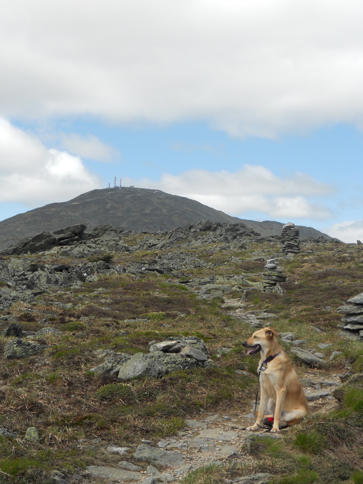
7) A trail I had initially thought about doing with one of the dogs. Goes up to Carter Dome. Yikes. Glad we didn't do that. Seems a bit too much of a rock scramble for dog paws.
8) Notice the chunk of missing flesh from my hand. They don't call it the "Granite State" for nothing.
9) Nia on the drive home. Tuckered out.


Sunday, June 24, 2012

Kinsman Pond Hut (overnight)


With a buddy from work and the elder canine (Sierra) in tow, we headed for Lafayette Trailhead in Franconia Notch. We departed through Lafayette Campground. The going was rough in the beginning. My trail amigo was feeling under the weather, but soldiered on (kudos to him for this!). We pushed onward, switchbacking hard two times. The trailed level off, and we enjoyed the flattening out towards Lonesome Lake.

The winds in the Notch were coming off the water of Lonesome Lake and cutting through the trees. It was refreshing to say the least. We sailed around the southeastern edge of the Lake, making it to Lonesome Lake Hut. Here, we recharged: water, thought about getting some food, medicine for my compadre. About this time, the skies changed. We headed in to this trip fully aware of the weather forecast [scattered & severe t-storms, lightning, possibility of hail, gusts of wind, etc.]. We decided to let nature "do its thing." We tied Sierra to a post under an overhang near one of the bunk houses, unloaded some food, and chatted while watching the rain fall. It was never too bad. Just faint rolls of thunder. After maybe 20 minutes, the rain seemed light enough that we could soldier onward.

We packed up and headed out. I meant to bring us up Kinsman Pond Trail up to the hut. Due to my own misreading of signs and ignorance, we ended up taking Fishin' Jimmy Trail. There was a fair amount of up and down initially on this trail. I was still looking for Kinsman Trail, but we pushed on.

After maybe 45 minutes, the ascent began. My interpretation of the trail: rocks. Up. Rocks. Up. Repeat for an hour and 30 minutes. Sierra is a champion backpacker, but she struggles when there is no trail and just rocks. Four or five times, there were wooden steps anchored to otherwise slippery, steep rock faces. So this turned into carrying her for sections of the hike. Mind you, I am carrying a 40 pound pack and have now added a 50-53 pound dog. The last time I hoisted her, I was not confident I could do it. Glad we both stuck with it though.

We continued our ascent. Sierra eventually gave up and laid down at one of our water breaks. Good dog! My trail amigo and I chatted about the semantic difference between "climbing" and "hiking." This trailed seemed to lean a bit more towards the former, and less towards the latter. Regardless of the amount of sweat and lactic acid, we made the best of it.

We crested a batch of rocks, and we saw the sign notifying us that the campsite at Kinsman Pond was coming up. Excellent. A bit more ascending, a bit more, a bit more ... and then we saw the caretakers white tent through the trees. Score.

We circled through the tent platform sites: no dice. They were all taken. This was particularly disheartening since both I and my trail amigo were carrying tents. We headed to the hut, claimed a spot, and rolled out our sleeping pads and bags.

Fired up the stove, made dinner, fed Sierra, filtered some water. And about this time, the real storm rolled in. It was quick (maybe 30 minutes) but it did include the following: thunder, lightning, torrential rain (as in, buckets), and some hail to top it all off. Ha, hail. Awesome, especially because I was in a dry shelter. [A note about this shelter: Rebuilt in 2007, this shelter is quite nice. Large doorway, elevated and floor sleeping areas. Pegs for drying gear. Not a lick of "carvings" in the wood. Let's keep it that way, eh? I recommend making the trip and checking it out.]  

Some late arrivals showed up soaked to the bone. Plenty of room in the shelter. The hut slept 8 (plus 2 dogs) comfortably. My trail amigo and I sipped some adult potables, traded stories, and called it a night.  Evening temps were a balmy 48 degrees, but it was actually really nice. I'll take that over the warmth of black fly season any day.

Sleeping was not so great. Sierra thought we should get up at 3:00 am. Bad dog. I held her still until other started to stir. We rolled up of our sleeping pads, ate some oatmeal, fed Sierra, packed up, and headed down. This time, we were headed down Kinsman Trail Pond on the south side of the pond. Now, this trail is more of a brook than a trail. Imagine boulders varying in sizes: the size of a computer printer ... to, say, the size of your average Honda Civic. This continued for what felt like an inordinately long time. Ultimately, this section of the trail we were doing was only 2.5 miles. Those slippery, wet, slime covered rocks made it feel like much longer. Somewhere after all the rocks, we were to forge a steam. I made a misstep and landed hip deep in refreshingly cool mountain water. Boots, socks, shorts ...  totally water logged. Meh, that's hiking!

We eventually converged with Cascade Brook Trail. Here, we took a left and ascended back up to Lonesome Lake Hut. This was only .8 miles, but again, a fair amount of rock hopping. We arrived at the hut. My trail amigo refilled his water, and I sat by the lake staring at Franconia Ridge bathed in 9 am sunlight. Then I laid down, pondering the quiet of the blue sky. A swim. Why not? I tied off Sierra, my trail amigo offered me his towel, and I dove in to Lonesome Lake. A invigorating dip after a sweaty morning. I got out and the wind coming across the lake wailed to life. I crouched behind my pack, blotting the wet spots where I could feel the chill the most. After changing and getting some food and water, we headed back towards the trail we came up and descended.

I cleaned Sierra's feet in the accompanying brook near the trail head [so much mud on her], got in the car, and coasted home.

This trip was a true pleasure, given what the forecast had me believing it may be like.
See you out there!

Pictures [didn't have the camera, so I used Google Images to give you an idea of what it was like. I do not own these photos.]: 

1) Rough map of the area we hiked.
2) View across Lonesome Lake [background is Franconia Ridge]. Stunning, I know.
3) "The steps" on Fishin' Jimmy Trail
4) Kinsman Pond Hut
5) Kinsman Pond


Wednesday, August 3, 2011

Overnight on Mount Liberty, NH

I carefully checked the weather, looking for cool periods during the week. This first week of August made an overnight on Liberty Spring Trail ideal. Packed my pack, packed Sierra’s pack, bid adieu to my beautiful wife and the puppy. And we were off.

DAY 1
Left early Wednesday so I would not have any trouble getting a tent platform at Liberty Spring. We parked at the Flume Gorge parking area and walked the bike path to the trail head — an anxious 9/10 mile. We found the trail head, took a pic or two, and started our ascent. The trail was fairly easy at first. Sierra was doing great with her own water and supplies in her pack. After the “Mt. Washington Incident” [i.e.: carrying too much water/cramping], I decided that maybe Sierra could make things a smidgen easier on me. She seemed happy to oblige. “Good dog!”

6/10 mile in, we hit the Flume Trail split. This trail is a rock scramble: not ideal for dogs. We turned left and knew we had 2 miles until the tent sites. Maybe 4/10 mile in, the true ascent started, and it really was pretty steady all the way up. The rocks were good stepping stones for much of the trail, and we met two thru-hikers going up. They seemed smitten with: 1) the cooler temperature & 2) the White Mountains in general. They blazed past us as I consumed some food and hydrated Sierra. At this point, I am pouring sweat. Covered. My shirts, a dish towel. My shorts, a sponge. I glanced at Sierra and wondered if evolution gave dogs the upper hand on cooling themselves.

We pushed forward, more rocks, steeper, more rocks. Then a white tarp. It was the caretaker’s shelter for the tent sites. I was thrilled. We pushed forward another 50 yards, and come to a three-way: left--the tent sites; straight--Mt. Liberty after 3/10 mile; and right--the water spring. I hoist off my pack and secure Sierra to a tree. I place my water bottle under the dripping spring and wait, noticing my own sweat pooling in the dirt near-by. I am hot, but thrilled to be here. After getting fresh water, we head into the tenting area. It is one long trail with offshoots for the privy, dishwashing station, and 10 different areas to camp. The tent platforms are well built and many of the first sites say “Large groups only” so Sierra and I keep heading in. I had pondered a certain site or two for privacy, and to my pleasure, site 10 at the end of the trail was empty — and now our home for the afternoon and evening.

Someone had left rope for a drying station. Excellent, shirt goes off and on to the rope. Next, comes the tent. I use much of the left over rope for helping to secure the tent and rainfly to the platform. Once setup, the tent area looks great. We’re spilling over the left side, but who cares. All the while, Sierra is investigating a nearby patch of roots. Next, the bear bag. Rope went up and over two trees; carabiner secured; food goes up [the tent caretaker later told me I had the best bear bag hang he’d ever seen in the campsite. Score].

After camp is set up, I decide we should make our way to the top of Mt. Liberty. It is 3/10 mile to a trail juncture, then another 1/2 mile to the peak. We start hauling. Everyone is thrilled to see Sierra and her pack. We reach a nice area to view the peak — being only 2/10 mile out. Snap some pics, and then over to the peak. Wind blowing and feeling great. I collect myself, we both get some water, and then back down to camp.

Once down, I decide it’s time for dinner — as I am ravenous. Rice and chicken one-pot meal. Things go off without a hitch, and I feed Sierra while my water is boiling. We sit for a bit, relax, take in the cool temperature and fading sunlight through the trees. A chill settles on the west side of the mountain where we’re camping. The caretaker, Flamingo, comes in. We chat about my plans, hikes to do in the Whites, his job, my job, and I pay the overnight fee. Once he leaves, I feel tired. We head in to the tent, and both human and dog fall to sleep.

DAY 2
Sierra awakes at 5 am. I am not ready to be awake. I settle her back down and rest until 5:45, when I hear others stirring in nearby sites. I feed Sierra, grab my food bag, pack the water, and we start another ascent. I decided to let Sierra slack-pack this morning, as I only carry two water bottles for us both and decide to take it easy on her. As opposed to bagging Liberty again, I head left/north at the juncture up from the tent platforms ... following Franconia Ridge trail over to Falling Waters Trail. It is a “down-then up again.” Part nature walk, part knee busting rock scramble. Sierra preforms like a professional. The clouds are low. Much of the fog in the valley hasn’t burnt off either. The sun leaks through the low conifers. Clouds bleed through the branches, and a nice chill keeps up cool. We reach Mt. Haystack, and I fire up my oatmeal. I check Sierra’s feet, and there are two exposed areas on both front paws. She appears to be unfazed by the peeling though, so I assume she’s doing OK. Out come the booties, as this is becoming “old hat” for us [see Mt. Washington blog entry].

I finish breakfast, pack up, and head back from where we came. Would’ve liked to get Mount Lincoln [the 4000-footer before Mt. Lafyette] in, but Sierra’s feet had me feeling cautious. And to be honest, the trip had been great so far. No reason to needlessly push it. We had back for the “down-then up” again. This time, it feels much easier. Sierra has trouble with one descent so decides to “slide” down a rock, using her booties as skis. I am amazed at her gumption for blazing trail. The ascent this time around is nice: woodsy, balsam in the air, stronger sun, and the dying breeze. We hit the junction and say hello to some kids [one who remarked of Sierra: “She’s a pro!”; I couldn’t agree more]. We descend back to the camp site. I pack up while Sierra naps in the tent with the door open. Finally, I give her the proverbial “boot,” pack the tent, and we’re ready to leave.

The descent is tiring. Very fast, thanks to Sierra’s pace. Again, I am pouring sweat, but it all feels good. We pass several hikers. I notice the vegetation changing, and we can hear the traffic on 93 near Franconia Notch. After a brook crossing, I know we’re almost there. Sierra, sensing that our hike is coming to a close, turns on the after burners. This exhausts me. It is hard keeping up with her, but her joy for coming down rubs off on me. We turn a corner and notice the bike path. Joyous day. Only the 9/10 mile walk back to the car. It is paved, but I am spent. Sierra also seems to be spent, as indicated by her totally slack leash. We make it back. I grab a pic of us at the bottom, collect myself, give Sierra water, and we pack up in the car. Sierra is asleep in 2 seconds. Ah, to be a dog.

I stop for food on the way home. Tunes on, the sun out, and a sleeping pup in the back. We make it home. I am happy to see Mel, Nia ... and our big soft bed.

Happy hiking.


Pictures


Friday, May 27, 2011

Hiking Mt. Killington in Vermont

We decided to camp in Mt. Ascutney this weekend. Sierra had been here once before, during the fall of 2009 - age, 5 months. She had a rough time then, shivering through the night & her stomach was upset. This time around though she was a pro camper: sitting quietly watching the other dogs in the site “across the way” & napping after our hike.

When we left for the hike, it was cloudy all morning, so we had faith that the hike wasn’t going to be too hot. If anything, we were hoping to avoid any rain storms. Hiking Killington started with a nice drive into the woods. The trailhead wasn’t too crowded, & we started out at a good clip. The first 1.5-2 miles of this hike is pretty level — or at least a very, very subtle grade: more of a walk in the woods than anything else.

Then began the ascent: a soul-crushing, thigh-burning, heart-exploding 1.5 miles. There were many bugs when we stopped to hydrate, but they weren’t really biting. About 1/2 way up, we started getting some of the winds cutting through the trees. That cooled us off and about that time our pace was tempered by a more level climb too the top of the mountain.

We hit Cooper Lodge just before the peak. It seems to be viciously vandalized by hoodlums ... fairly regularly. Next, a rocky ascent for maybe .2 miles, and then the summit in the clouds (see pic above). We got some snacks, water, cooled off, and started making our descent — as it was a bit chilly up top.

Heading down the same trail we ascended, the sun came out. The temperature climbed, and we were pretty thankful that we did not have to ascend the 1.5 miles in that sort of sun/heat. We reached the level part of the trail and enjoyed the rest of our walk in the woods. Shortly before getting back, we all took a moment to cool ourselves in the stream paralleling the trail as we returned to the trailhead.

Another 4000-footer in the bag. BAM.

Happy hiking.


Pictures


Saturday, March 19, 2011

Mt. Morgan & Mt. Perceval

Back in 2010, we made it to the top of Mt. Morgan. Sierra, as always, was a pro. Second time around, we headed to the northwest area of Squam Lake in NH to bag both Mt. Morgan and Mt. Perceval. We left our house pretty early to get up north and get on the trail to “beat the crowds.” In characteristic over-doing-it fashion, we see barely anyone. It was, however, a crystal clear day. Things were looking good for a great hike all around. We also were sure to bring Sierra’s backpack, so she could get a bit of “working” in during the hike.

With our snowshoes on, we blazed through the woods. Sierra was doing great. There were quite a few shallow streams from early spring runoff. Nothing like the soothing sounds of crampon teeth against granite. A bit of the ways in, we reach a bridge. Let me nix that. We reached what used to be a bridge. Winter had not been kind to the logs, and we had to find our way around the rushing water and deep drifts at the lip of the rushing water. Sierra, like a champion, did great.

We continued on. The thing about hiking with Sierra when she’s doing great is her pace ... as in, she doesn’t have one. It is more like a steady sprint to the top of the mountain. End result: Sierra gets to practice her “Wait” command quite a bit. Not a horrible thing all-in-all. After Sierra broke through some of the deep snow with her skinny legs, we started the final ascent. We all took it like the true Sherpas we aspire to be like.

After 10-15 more minutes, we make to the top of Mt. Perceval. We snap some pics, eat some more goodies, get some water and take in the amazing views: mountains to the north, lakes to the east [Squam & Winnipesaukee], and stately looking conifers to the west.  

In time, we pack up and keep pushing on the loop to Mt. Morgan. Writing this from memory: I am not sure of the mileage for many of the details heading down. But I remember truly enjoying the hike up. The hike down was only challenging with Sierra pulling a bit — as we tried to balance ourselves on steep snowy hills.

We stop once to snap some more pics and then decide to push on ahead, back to the trailhead. With about .5 miles to go, Sierra catches scent of the fact that we’re almost back to the car. So began her showing off with Olympic-like strength. In time, we got to the bottom: tired but not so tired that we couldn’t enjoy the drive home through a stellar area in NH.

A beautiful winter hike for us.

Happy snowshoeing.

Pictures


Saturday, January 15, 2011

Skijoring & Snowshoeing

Beaver Brook, just west of Nashua, is one of our favorite local areas to walk Sierra. A myriad of trails. Perfect for cross-country skiing/skijoring, some light sledding, hiking, or snowshoeing. Or simply taking a walk. After a hefty winter storm this past January, we headed out into the wilderness on both Saturday and Sunday morning to get our outdoor fix.

Day 1: Skijoring. Sierra has caught on pretty quick this winter. She still struggles with stopping to take in the smells of the area. But hey, we love her anyways. Mel and I both took turns hooking up the belt to get some time in with “dog power” — which makes skiing all the more difficult for the person without a dog. We had good runs both into the woods and on our way out.

Day 2: Snowshoeing. Taking our favorite trails ... but this time in some unspoiled areas of fresh snow. On a day like this, it is easy to see that Sierra loves being outdoors and working.

At the end of the weekend, we were tired — but in that good way. A classic (and ideal) winter weekend for us. We loved every second of it.

Happy winter trails!


Pictures


Friday, June 4, 2010

Mt. Washington

Melissa was out of town, so I decided Sierra and I should share some quality time ... in the form of a thigh-busting hike. We stayed in Driver River Campground (Crawford Notch) in the White Mountains. Very few people were staying there. All-in-all, a peaceful experience.

We awake early Saturday to head over to Pinkham Notch, as I know it will take several hours to make the top [via Glen Boulder Trail]. 1.5 miles in, we cross a rushing brook by foot bridge. So begins the overgrown thickets of the trail. Things feel wrong, but for some reason I plunge ahead. After .8 miles (do not laugh), I realize we are not gaining the elevation we need to, and we are not switchbacking to the summit. With much irritation, I decide to turn around, and we lug ourselves back up the hills, another .8 miles. Shortly before the aforementioned rushing brook/foot bridge, there is a steep turn off. On the way back, Sierra catches sight of it and starts heading up. I am angry we have hiked so much and done so little to get to the top of the mountain. I am now more resolved than ever to reach the top though. So began the true hike.

After a bit, I notice we have hiked 3.5 miles. I am drenched with the sweat, but Sierra is still looking strong. After about an hour, we reach Glen Boulder (see above), which is a great place for us to rest and get out of the sun after hiking as much as we have done. A first for me though: my thighs are cramping every 5-10 minutes. Sierra is not impressed. I am equally as unimpressed. I hydrate constantly, trying to do the same for Sierra. She seems fine. I, on the other hand, am passed by 4 people over the course of an hour. I begin to recognize that this is my worst showing as a hiker to date.

We begin making our way to the Boot Spur. Now, the guide book I was using was sure to note that Mt. Washington is nicknamed “the rock heap.” At this point in the hike I am placing expletives before its nickname. At one of my “cramping pitstops,” I decide to check Sierra’s feet — since so much of the trail has been rock. To my non-surprise, both back feet are bleeding, ever so slightly. I am now cursing myself. 4 to 4.5 miles into this hike, I am cramping every 3 seconds, Sierra is bleeding, and I realize now that there is only one way down: up.

Safety first! I had packed Sierra’s “dog booties” for a situation just like this, and I place them on her back feet. So begins the every-75-yards-process of turning said booties around, as they would get twisted as Sierra dragged her feet across the rocks on ascents. At each rest, we both seem pooped. I admit to myself that my neo-Thoreauvian attitude is on empty. Sierra and I begin hiking on pure adrenaline (read: rage).

On “the flats” (before the last push to the summit), we pass a trail sign. “Mt. Washington — 1.0 mile” it reads. I am simultaneously elated and heartbroken. The last .5 mile feels the hardest. While I know that is certainly not empirically accurate, my thighs, brain and emotions do not care. We are dragging.

At each “mini-break” on the way to the top, we chat with solo hikers, families of four, and gaggles of Europeans. All who seemingly have the emotional fortitude of Rocky and the wind stamina of Brazilian soccer phenom PelĂ©. Eventually, the rise of boulders give way to herds of tourists and weather/radio towers. With no wind on top and the temperature holding at a balmy 48 degrees, I feel as though we are rewarded for hiking through this emotional gauntlet: a perfect day on Mt. Washington. Needless to say, it was worth it.

I decide it is best to descend in a van via the auto-road — as Sierra’s front feet also started looking a bit raw. We snap some pics, sit on a bench for a bit, say hello to children and parents who want to pet Sierra, and we wait for our ride down. A challenging hike that I would most likely never do again with a dog (Let that be a note to you dog owner/reader).

That said, we certainly felt like stone cold champions. Sierra was exhausted. I was exhausted. After being bussed back to Pinkham Notch where our truck was waiting for us, we beelined it back to camp and headed home.

Tallest peak in the northeast, “check.” What else ya got?

Happy hiking.


Pictures